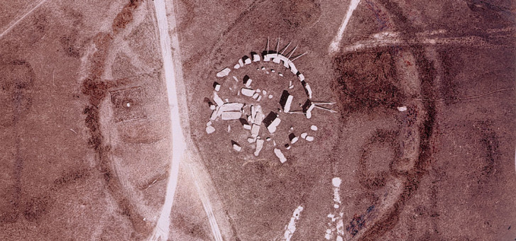
We have entered an exciting new era for archaeology. Satellite and aerial imaging is revolutionising the way that archaeologists work and how we detect the past. This technology is certainly a far cry from its beginnings in the autumn 1906 when one Lt. Philip Henry Sharp took to the air in a woven basket suspended beneath an army hydrogen balloon and flew over Stonehenge, snapping the first aerial photo of the famous site.
But even then, archaeologists could see that Sharpe’s photos were the beginning of something exciting for the future of archaeology. Osbert Guy Stanhope Crawford, a contemporary archaeologist, dreamed that one day in the future, field archaeologists would become like the birds!
These days, technology has turned Crawford’s dream into reality. Today, archaeologists can use imaging from NASA and commercial satellites orbiting at 700 kilometres (430 miles) above the earth. Pioneering this field of expertise is Dr Sarah Parcak from the University of Alabama in Birmingham. Over the last five years Dr Parcak has utilised infra-red satellite imagery to locate over 1000 tombs, 3000 settlements and 17 pyramids lying just under the surface of the sands of Egypt which the naked eye has never been able to detect.
Whereas the human eye detects only the colours of the spectrum, infra-red technology can detect density, even under the ground’s surface, and since mud-bricks of the type used in ancient Egypt have a higher density than sand, they show up under infra-red imaging from the satellites, even if they lie buried under that sand. Once the images are taken by satellite, the data is then beamed back to Parcak’s computer which allows her to see many different and varied ancient sites throughout Egypt that lay hidden from view for literally thousands of years.
Perhaps Dr Parcak’s proudest achievement in using this advanced technology is the discovery of Tanis, one of ancient Egypt’s greatest capitals of the second millennium b.c., which has lain hidden under the silt of the Nile Delta for some three millennia. Using infra-red satellite imaging, Parcak was able to not just see Tanis but also to comprehensively map it out.
“From space you can see the whole settlement’s detailed network of streets and houses,” she comments. “Our map is incredibly clear; it literally looks like something you’d pull out to help you navigate a town you might visit today.”
According to Parcak, this is only the start of where new technology will lead archaeologists. “There are many thousands of additional sites that the Nile has covered over with silt. This is just the beginning of this kind of work.”
Archaeologists across the world are beginning to use the same or similar technology, with fantastic results. And not surprisingly, because it saves a lot of time and thus a lot money. What once could take up to four years to pinpoint can now be done in a matter of weeks.
In Cambodia, Dr Damian Evans of the University of Sydney, Australia, had utilised light radar and powerful GPS technology to locate Lingapura, the lost, ancient capital of the Angkorian empire. Dr Jason Ur from Harvard University has also had his own breakthrough, identifying some 1200 sites in Iraq utilising 1960s spy-satellite images, which, he believes, make up “the richest archaeological landscape in the Middle East.” The technology has also located camoflaged Mayan cities in the jungle of Guatemala and helped unlock the secrets of the construction of the moai head-statues of Easter Island. In summary, satellite technology is revolutionising the way we approach archaeology.
You don’t have to be a university professor or profes- sional archaeologist to make a major discovery, either. A few years ago, from the comfort of her home in North Carolina, Angela Micol used Google Earth to locate two pyramidal mounts, one near the Fayum Oasis and the other near the city of Abu Sidhum, Egypt, which she thought might actually be long-lost pyramids. What’s more, she might be right!
Despite the concerns of sceptics, an expedition team was sent to the site at Abu Sidhum and detected metals and an underground tunnel under Micol’s pyramidal mount, possible proof that this extremely weathered, but pyramid-shaped mound might have once been a royal pyramid. Micol says her goal now is to travel to Egypt with a team of scientists and videographers to prove whether the two sites she found on Google Earth really are long-lost ancient pyramid complexes.
But air-imaging isn’t only useful for identifying hidden important archaeological sites. In fact, it’s being used as a means of surveying and recording an archaeological excavation itself, albeit from a lower altitude. Perhaps the most important use of aerial photography today for the purpose of recording the archaeological data taken during actual digs is low-level aerial photography. In recent years the field archaeologist, British Royal engineer and professional photographer of 20 years, Adam Stanford, has led the way in this area, having developed “Aerial- Cam,” which is now being used across the globe to record archaeological sites.
Early days
The era of aerial photography arrived with the develpment of the spotter planes over the trenches in World War 1, which contemporaries believed would be as revolutionary for archaeology as the telescope was for astronomy. This was turned to civilian uses in the 1920s when an Austral- ian archaeologist, Vere Gordon Childe, educated at the University of Sydney and Oxford University, began using aerial photography over the Orkney Islands. He located the Neolithic site now called Skara Brae. A Marxist at heart, Childe hoped to find an ancient Marxist-style utopia and in 1927, he found something there which reflected this view.
Childe identified and excavated the ruins of a number of house-dwellings, all built close to one another thousands of years ago and all virtually of the same size, suggesting the existence of some kind of a close-knit, egalitarian community. Of course, the ancient dwellers of Skara Brae knew nothing about Marx, but Childe’s discovery and excavation there marked a shift in archaeology away from merely recovering information about the ancient world’s elite like pharaohs, kings and emperors and toward a better understanding of everyday interaction between ordinary people in the society of millennia ago.
A new view
After World War II, low-level aerial photography became more popular at important dig sites. First, platforms and extension ladders were utilised, then later scaffolding and cherry-pickers, as well as Unmanned Aerial Vehicles (UAV) such as kites, blimps and remote-control aircraft, allowing greater manoeuvrability and improved perspective. But a breakthrough came in 1970 when the Royal Commis- sion on the Ancient and Historical Monuments of Wales invented the “High-Spy” camera. A camera was fixed to a telescopic mast, which was mounted to the back of a Land Rover to access even the most remote archaeological sites. However, at the time, the technology was still basic and so expensive that few archaeologists used it.
Up a pole
In 2006, this changed when Adam Stanford developed his own form of “high-spy”—Aerial-Cam—using far more advanced and affordable technology. Aerial-Cam employs a high-resolution (12.3mp) Nikon Digital SLR camera mounted atop a 22-metre (70 feet) telescopic mast, the optimum height for the best detailed and accurate photo-taking of dig sites. The mast itself is fastened to the rear corner of a four-wheel drive, giving it a steady, sturdy base. The mast is then extended into the air and the camera lens view atop it is fed back to a monitor on ground level via a boosted USB connection. This allows the project direc- tor or supervisor at any dig site the great luxury of being involved in the photographic capturing process itself, as well as camera pointing, focussing, speed, aperture and so on. Once Aerial-Cam has taken its photos overlooking the excavation site, those photos can then be written to CD or uploaded directly to some remote location for storage, analysis, dissemination and publication even while the excavation is being undertaken.
There are a number of advantages for the archaeolo- gist. As Stanford explains, it allows for a more detailed and accurate recording of excavations and findings. “As archaeological excavation is a destructive process, and in a lot of cases the evidence will only be available for recording for a relatively brief window of opportunity, I feel it’s very important to ensure the photographic record is of the highest quality possible. Hence my insistence on using the best cameras available!”
The use of high quality cameras atop a 22-metre (72 feet) mast means that archaeologists can achieve far more detailed images than what one gets from planes, drones or satellite. And there are other uses at any dig site already excavated. Notes Stanford: “Close study of the images as they are taken has in some cases led to the discovery of features that have previously not been noticed.”
Stanford has even allowed for use of the technology to those areas which are too inaccessible for a four-wheel drive. He has developed a lightweight tripod that can be carried to those sites too difficult to reach by vehicle. But, for the moment, this method has less potential for height, as the tripod only supports a shorter mast.
Stanford’s work is a welcome addition to both present- day and future archaeology; Aerial-Cam is now used by commercial archaeologists, university field studies teams and other special project workers across a range of archaeological sites, from the pre-historic to contem- porary industrial.
Technology is catching up to what archaeologists of the past could once only have dreamed about: a bird’s-eye-view. As technology progresses ever further and economies improve, no doubt that technology will become ever more available to locating, identifying and recording many more important archaeological sites all over the world, strengthening our own connections with our ancestors and humanity’s common ancient heritage. As Dr Parcak puts it, new technology make us “think bigger, and that’s what satellites allow us to do. Indiana Jones is old school; we’ve moved on from Indy. Sorry, Harrison Ford.”
Methods of Photography
Remote, low-level aerial photography like that done by Adam Stanford of Aerial- Cam provides safe, cost-effective ways of recording excavation sites, utilising a variety of techniques for detailed, high quality images.
Traditionally, aerial photographs are taken by aircraft or by setting up high scaffolds, which are both costly and time consuming. With today’s remote technology, cameras can be controlled from gound level, opening up solutions such as:
- A remote camera atop a 22-metre telescopic mast fixed to a Land Rover.
- Kite-Cam and aerial drones, known as RPAs (Remotely Piloted Aircraft).
- Hand-held Pole-Cam, a mast for walking surverys similar to the Tri-Frame mounted Mast-Cam used for building interiors
